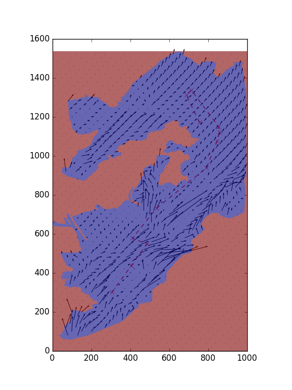


| X | Y | LONGITUDE | LATITUDE | HEADING | DISTANCE | DISTANCE_ACCUM | DURATION | DURATION_ACCUM | WORK | WORK_ACCUM | |
|---|---|---|---|---|---|---|---|---|---|---|---|
| 0 | 756.000000 | 362.000000 | -70.864409 | 42.536620 | 0.000000 | 0.000000 | 0.000000 | 0.000000 | 0.000000 | 0.000000 | 0.000000 |
| 1 | 688.110341 | 221.883883 | -70.866673 | 42.541293 | 2.021987 | 108.094990 | 108.094990 | 10.809499 | 10.809499 | 3157.157285 | 3157.157285 |
| 2 | 714.176230 | 197.232703 | -70.865804 | 42.542115 | 0.757511 | 35.876333 | 143.971323 | 3.587633 | 14.397132 | 994.837467 | 4151.994752 |
| 3 | 854.469798 | 385.083172 | -70.861124 | 42.535850 | 0.929323 | 234.456999 | 378.428322 | 23.445700 | 37.842832 | 6962.168202 | 11114.162954 |
| 4 | 858.770715 | 411.690158 | -70.860980 | 42.534962 | 1.410536 | 26.952358 | 405.380679 | 2.695236 | 40.538068 | 994.219106 | 12108.382060 |
| 5 | 846.447093 | 458.434261 | -70.861391 | 42.533403 | 1.828571 | 48.341315 | 453.721995 | 4.834132 | 45.372199 | 1772.221235 | 13880.603295 |
| 6 | 792.071635 | 595.834378 | -70.863205 | 42.528820 | 1.947630 | 147.768341 | 601.490336 | 14.776834 | 60.149034 | 5103.400919 | 18984.004213 |
| 7 | 535.265317 | 802.727480 | -70.871772 | 42.521920 | 2.463423 | 329.779079 | 931.269415 | 32.977908 | 93.126941 | 9595.481859 | 28579.486073 |
| 8 | 411.838340 | 956.107132 | -70.875889 | 42.516804 | 2.248406 | 196.874417 | 1128.143832 | 19.687442 | 112.814383 | 5727.207264 | 34306.693336 |
| 9 | 485.044595 | 986.195727 | -70.873447 | 42.515800 | 0.389963 | 79.148463 | 1207.292295 | 7.914846 | 120.729230 | 2707.174915 | 37013.868251 |
| 10 | 405.859739 | 1097.582622 | -70.876089 | 42.512085 | 2.188800 | 136.664852 | 1343.957147 | 13.666485 | 134.395715 | 4185.177685 | 41199.045936 |
| 11 | 306.000000 | 1233.000000 | -70.879420 | 42.507569 | 2.206199 | 168.255264 | 1512.212411 | 16.825526 | 151.221241 | 5062.852850 | 46261.898786 |
Region
Geotiff raster file: ../DataLayers/scenario1/Map/regionLand_2.tif
Rows: 1535
Cols: 1000
Time Frame
Start: 02/21/2018_20:54:50
Stop: 02/22/2018_20:54:50
Resolution (minutes): 1440
ROMS Data Source
URL: http://www.smast.umassd.edu:8080/thredds/dodsC/FVCOM/NECOFS/Forecasts/NECOFS_FVCOM_OCEAN_MASSBAY_FORECAST.nc
Water Currents
Magnitude geotiff raster file: testCurrentsMagitude.tif
Direction geotiff raster file: testCurrentsDirection.tif
Vehicle
Start position: (Latitude: 42.5366, Longitude: -70.8644
Target speed: 10
Optimization Parameters
Number of waypoints: 10
Generations: 100
Individuals: 50